For nine days during 2024, uncrewed surface vehicle (USV) manufacturer SeaTrac and underwater technology company Sonardyne collaborated to remotely measure currents and gather oceanographic data in the U.S. Gulf of Mexico’s Loop Current System (LCS).
Understanding the LCS is crucial for subsea operations, hurricane research, monitoring marine life and more. However, collecting such data at sea via traditional manned vessels brings risk to on-board crews and generates high operational costs, while also emitting harmful greenhouse gases.
Representing the first of four project phases for the University of Rhode Island (URI), funded by the U.S. National Academy of Sciences, this initial mission demonstrated the feasibility and benefits of using SeaTrac’s USV equipped with Sonardyne’s advanced acoustic technology in lieu of manned vessels to collect data from offshore seabed sensors.
SeaTrac’s SP-48 USV is a solar- and battery-powered vehicle capable of operating up to months at a time in a variety of marine domains, including challenging offshore conditions. SeaTrac integrated a Sonardyne HPT 7000L transceiver aboard the USV to enable acoustic data harvesting from offshore seabed sensors.
Prior to the first phase initiation, Sonardyne and URI deployed Origin 65 Acoustic Doppler Current Profilers (ADCPs) and Current Pressure Inverted Echo Sounders (CPIES) on the seabed of offshore U.S. Gulf waters to collect long-term data on the LCS. Nine sensors installed at depths ranging from 1,800 to 3,200m below sea level continuously measured ocean currents and other relevant parameters.
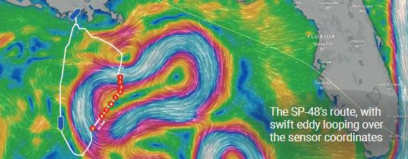
The SP-48 was deployed from the Louisiana Universities Marine Consortium (LUMCON) in Cocodrie, La. The SeaTrac team piloted the SP-48 from its remote operations center in Marblehead, Mass., and directed the USV 200 nautical miles offshore to the specified coordinates of the first seabed sensor.
Once in top-side position over the sensors, the USV’s HPT 7000L transceiver acoustically harvested the data and moved to each subsequent array element before returning to LUMCON. In total, the SP-48 covered over 580 nautical miles.
The offshore sensors could collect data but could not transmit it back to shore. Traditional methods of recovering the data require large, crewed ships operating far offshore, which put people at risk while generating high carbon emissions and operational costs. SeaTrac’s unmanned SP-48 and its Sonardyne payload technology remotely harvested the sensors’ data and relayed it to onshore researchers from sea at a fraction of the operational cost of a manned vessel, with no risk to humans.
The U.S. Gulf of Mexico presents harsh challenges due to notoriously strong currents, fast-moving eddies and unpredictable sea states. During this mission, an eddy formed atop the sensor locations. This made navigating to exact sensor coordinates, as well as remaining on station, a non-trivial task.
SeaTrac’s Dashboard software enabled dynamic and precise mission planning to navigate around and through eddy currents to the exact sensor locations. Once in position, SP-48’s large battery ensured sufficient propulsion to navigate through and hold station in currents exceeding three knots during the data harvesting.
The data collected will provide valuable insights into the LCS and its impact on marine life and operations. This data will be used to inform decision-making in areas such as offshore energy development, fisheries management, coastal planning and other ocean interests.
“The use of a fully solar-powered USV for a data gathering operation of this scale is a key moment in marine robotics. The Gulf of Mexico presents some of the most challenging ocean currents for any vessel, not least an uncrewed one. One of the key reasons SeaTrac was chosen was their willingness to rise to the challenge and we are delighted with the results,” said Aidan Thorn, Business Development Manager for Marine Robotics, Sonardyne.
The Sonardyne ADCP and CPIES sensors remain on the seafloor and continue to collect long-term LCS data. Through the summer of 2025, SeaTrac will harvest several additional sets of data, which will be transmitted over the horizon in real time via satellite connection from offshore staging points.

